Beyond the Blueprint: Turning Complex Data into Interactive Visual Stories
Beyond the Blueprint: Turning Complex Data into Interactive Visual Stories
In a world driven by data, communicating complex information effectively can make or break the success of a project. Whether designing a cityscape, planning infrastructure, or conducting environmental assessments, the ability to transform raw data into engaging, interactive visual stories is essential.
Traditional charts and reports often fail to resonate with diverse audiences. Aero AI bridges this gap, offering innovative tools that enable professionals to convert complex datasets into captivating narratives. These solutions empower teams to present their projects with clarity, precision, and impact.
Why Interactive Visual Stories Matter
Traditional methods of presenting data [static graphs, spreadsheets, or lengthy documents] can overwhelm stakeholders, creating barriers to understanding. Interactive visual stories transform these complexities into dynamic, easy-to-digest formats that engage and inform.
By bringing data to life, these tools enable audiences to:
Explore: Dive deep into specific project aspects.
Interact: Visualize scenarios and outcomes dynamically.
Connect: Understand data in a way that inspires confidence and action.
Aero AI Tools: Transforming Data into Stories
1. Geospatial 3D Models and Tiles
Aero AI’s geospatial 3D models create immersive, high-resolution visuals tailored for architecture, engineering, and construction (AEC) industries. Compatible with tools like AutoCAD and Rhino, these models enable:
-Enhanced collaboration
-Improved decision-making
2. 2D Orthomosaics
High-resolution orthomosaics from aerial imagery provide an accurate, bird’s-eye view essential for site analysis and planning. Key benefits include:
-Early risk information
-Reliable Documentation
3. CAD and BIM Models
Seamlessly converting point clouds into CAD/BIM files, Aero AI ensures that project designs align with real-world conditions. Benefits include:
-Streamlined workflows
-Reduced revisions
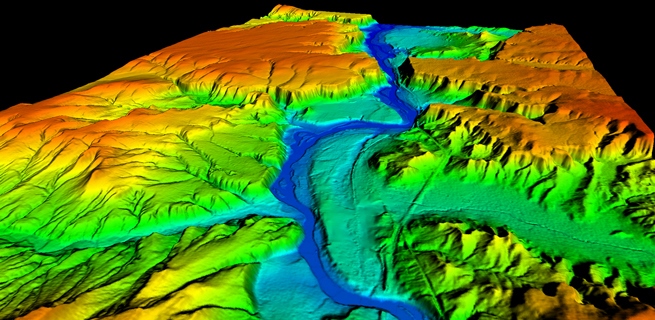
4. Digital Terrain and Surface Models (DTM/DSM)
DTMs and DSMs provide comprehensive topographical analyses:
-DTMs: Focus on ground-level details for efficient site planning.
-DSMs: Include above-ground features, ideal for solar energy or infrastructure optimization.
5. Thermal Maps and LiDAR Point Clouds Thermal Maps: Analyze temperature distributions for energy audits and environmental assessments. LiDAR Point Clouds: Capture detailed spatial representations for terrain mapping. These tools are invaluable for energy-efficient designs and robust infrastructure planning.
Challenges and Considerations
While these technologies offer transformative potential, successful implementation requires: Training, Data Quality, Cost Management
Future Trends
The future of data visualization lies in combining interactive storytelling with cutting-edge geospatial technologies. As industries increasingly rely on dynamic, data-driven insights, tools like Aero AI’s will lead the charge in reshaping communication and decision-making processes.
Transform your data into interactive visual stories with Aero AI. Request a free demo today and inspire confidence in every pitch!