Precision Aerial LiDAR for Infrastructure, Utilities & the Built Environment
High-Accuracy Mapping for Infrastructure, Utilities, and AEC Digital Twins
Corridor-scale mapping, digital twins, and analytics — powered by drone LiDAR and SiEGA visualization.
CLIENTS & PARTNERS


What We Deliver
AERO AI delivers turnkey aerial LiDAR services with high-fidelity processing and digital twin-ready outputs for infrastructure, utilities, and AEC projects — powered by advanced UAV technology and the SiEGA platform.
Turnkey Aerial LiDAR Capture
- UAV LiDAR capture
- Ground control & RTK workflows
- Vegetation-penetrating LiDAR for complex corridors
High-Fidelity Processing
- Enhanced point cloud registration
- Noise filtering + ground classification
- Feature extraction, DEM/DSM, profiles, sections
Digital Twin-Ready Outputs
- Classified LAS/LAZ
- Bare earth & utility models
- CAD/BIM integrations (Civil3D, Revit)
- Web-ready 3D Tiles for SiEGA/CorridorTwin
Infrastructure & Utilities
For power, telecom, pipelines, transportation
AEC & Digital Twins
For architects, engineers, general contractors, & owners
For power, telecom, pipelines, transportation
- ●Utility Corridor Mapping
- ●Powerline Clearance & Vegetation Encroachment
- ●Transportation & Roadway Design Surveys
- ●Pipeline Right-of-Way Monitoring
- ●Environmental Assessments / Flood Modeling
Why AERO AI?
AI-Enhanced Processing
Proprietary AI analytics and visualization provide insights others cannot.
FAA Part 107 Certified
Safe, legal missions flown by certified Part 107 pilots.
Complete Data Lifecycle
End-to-end handling: Capture, process, analyze, deliver.
Fast Turnaround
Rapid processing delivers results in days, not weeks.
Example Projects / Case Studies
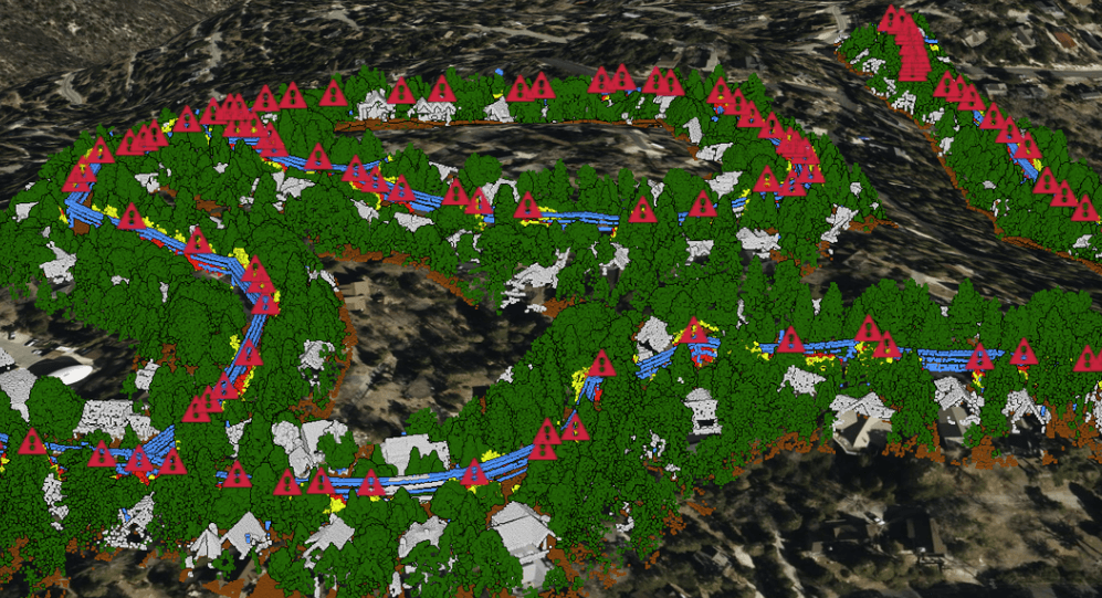
UTILITY VEGETATION MANAGEMENT (UVM)
Big Bear Corridor, CA
High-accuracy mapping for distribution-level utility vegetation management.
- Long-range UAV LiDAR capture.
- Vegetation clearance analysis and risk reporting.
- Rapid deployment for emergency response.
Deliverables
Integration with GIS and utility planning systems.
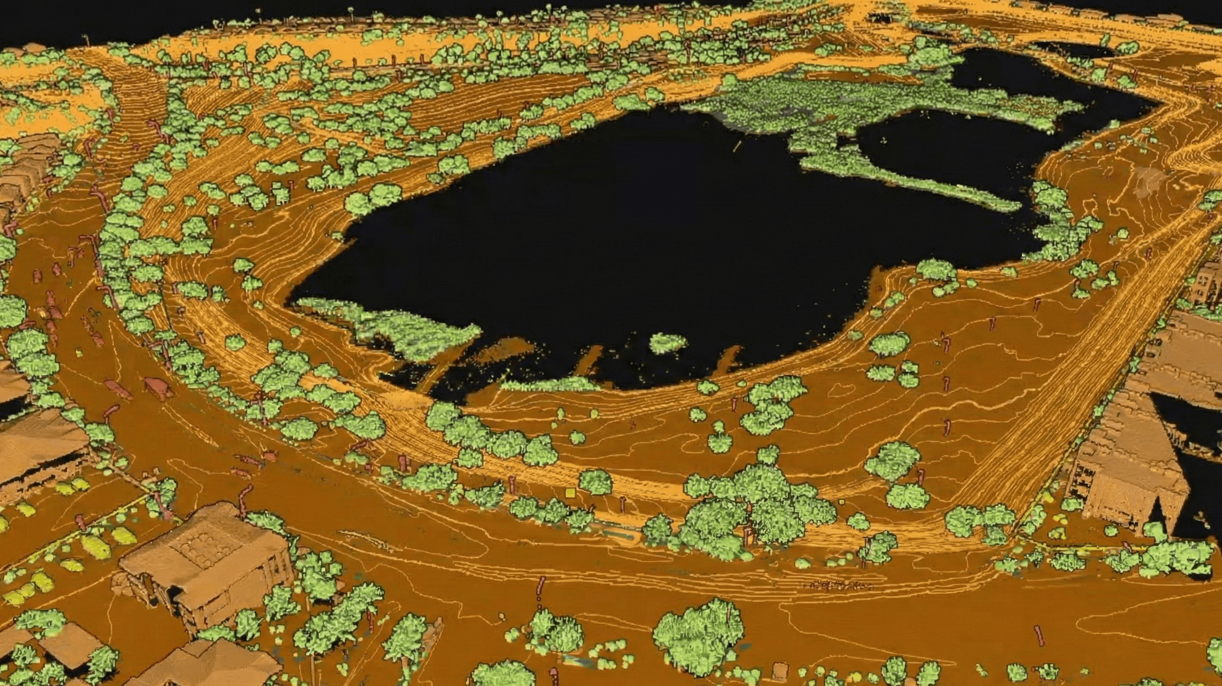
ENVIRONMENTAL MAPPING & WATERSHED ANALYSIS
Cornerstone Park, NV
High-resolution LiDAR mapping for lakeshore and open-space management.
- Vegetation structure analysis for habitat, wildfire, and maintenance planning.
- Contour and drainage modeling for flood and erosion monitoring.
- Hydrological assessment for water resource planning.
Deliverables
GIS-ready data for park planning, trails, ADA upgrades, and capital projects.
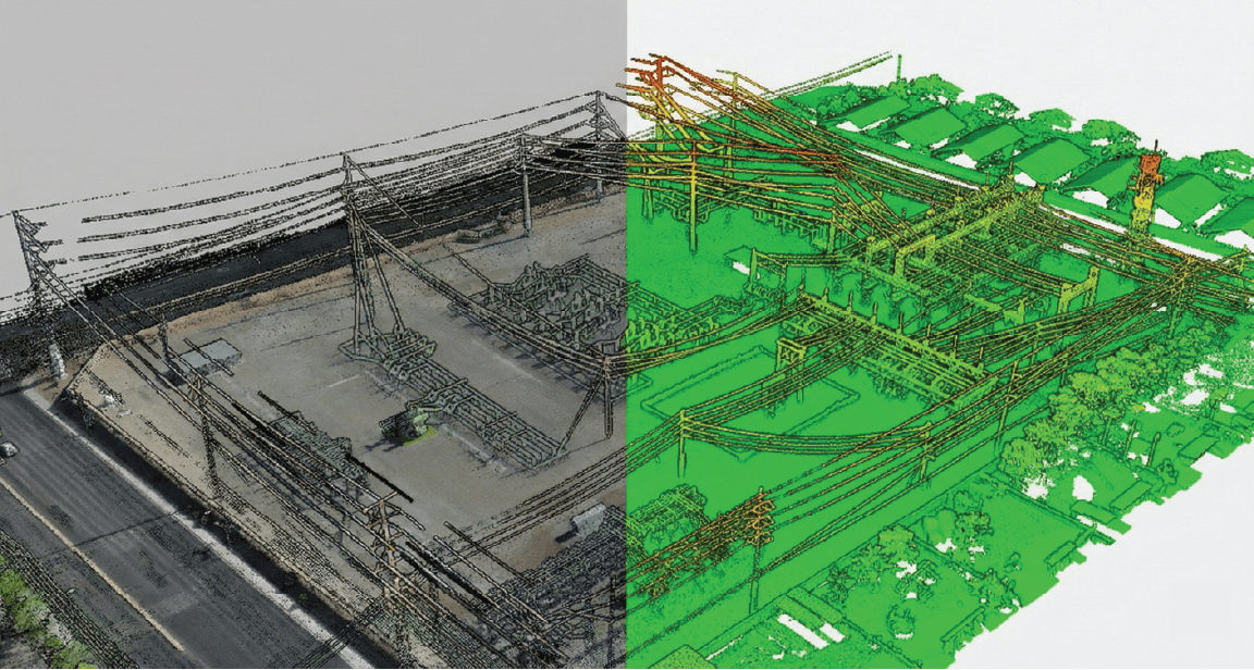
SUBSTATION DIGITAL TWIN & AS-BUILT INTELLIGENCE
Utility Substation Mapping
High-density LiDAR capture for substation digital twin and as-built intelligence.
- Millimeter-level accuracy for equipment positioning and safety analysis.
- Clearance, encroachment, and deformation analysis for compliance.
- Direct integration with GIS, CAD, and asset management systems.
Deliverables
Supports as-built verification, upgrades, and construction documentation.
Output Deliverables
Classified Point Clouds (LAS/LAZ)
DEM, DSM, DTM
Contours / Planimetrics
Utility modeling
Digital twin ready 3D Tiles
BIM models (LOD 200–350)
Vegetation / encroachment reports
High-Resolution Orthomosaics
Software Integration (SiEGA + CorridorTwin)
Real-Time 3D Visualization
- Stream large LiDAR datasets via web
- Annotate and measure precision data
- Generate instant shareable links
- Enable seamless team collaboration
Pricing Guidance
Flexible pricing models to match your project scope and requirements
Corridor LiDAR Mapping
$ per linear mile
AEC As-Built LiDAR
$$ per building
Digital Twin Pipeline
custom + subscription model
Ready to map your corridor or facility?
Speak to our LiDAR experts and explore how SiEGA delivers more value than a traditional scan.
Schedule Demo